-
This perspective view in Noctis Labyrinthus was generated from the main camera’s stereo channels on ESA’s Mars Express. It shows the beautiful details of landslides in the steep-sided walls of the flat-topped block in the foreground and in the valley walls in the background.ESA/DLR/FU Berlin
-
A view of the stunning central mesa inside Hebes Chasma. A horseshoe-shaped chunk has been taken out of one side of the mound (left in this image); the material has slumped down onto the floor of the valley below. A dark patch appears to pool like spilt ink across the debris. It is most likely loose material that has slid down the walls from an intermediate layer. Melted ice could have played a role by weakening the rocks to create its flow-like appearance.ESA/DLR/FU Berlin (G. Neukum)
-
An overview of the Hebes Chasma, an enclosed, almost 8km-deep trough stretching 315km in an east–west direction and 125km from north to south at its widest point. It sits about 300km north of the vast Valles Marineris canyon.ESA/DLR/FU Berlin (G. Neukum)
-
This sweeping view extends from the planet’s south polar ice cap and across its cratered highlands to the Hellas Basin (top left) and beyond.ESA/DLR/FU Berlin
-
The image shows part of the Arabia Terra region, which is scattered with craters of varying sizes and ages. The craters in this image, caused by impacts in Mars’ past, all show different degrees of erosion.ESA/DLR/FU Berlin
-
The bright white region of this image shows the icy cap that covers Mars’ south pole, composed of frozen water and carbon dioxide. While it looks smooth in this image, at close quarters the cap is a layered mix of peaks, troughs and flat plains. The southern cap reaches some 3km thick in places, and is around 350km in diameter.ESA/DLR/FU Berlin / Bill Dunford
-
View of an unnamed crater in the northern latitudes of Mars. The crater is 35km wide and has a maximum depth of approximately 2km beneath the crater rim. The circular patch of bright material located at the centre of the crater is residual water ice.ESA/DLR/FU Berlin (G. Neukum)
-
Neukum Crater and surrounding areas can be seen in 3D when viewed using red–green or red–blue glasses.ESA/DLR/FU Berlin
-
A close-up image of the Martian moon Phobos.ESA/DLR/FU Berlin (G. Neukum)
-
This image shows a part of the northern polar region of Mars at the northern hemisphere summer solstice. The polar ice deposits follow the seasonal cycles. The cap is covered by frozen water and carbon dioxide ice in winter and spring, but by this point in the Martian year all of the carbon dioxide ice has warmed and evaporated into the planet’s atmosphere. Only water ice is left behind, which shows up as bright white areas in this picture.ESA/DLR/FU Berlin (G. Neukum)
-
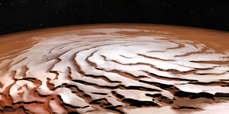
Perspective view of the Mars north polar ice cap and its distinctive dark troughs forming a spiral-like pattern.ESA/DLR/FU Berlin; NASA MGS MOLA Science Team
-
This image shows a region of the planet’s northern hemisphere known as Hephaestus Fossae. The image has been colored to indicate the elevation of the terrain: green and yellow shades represent shallow ground, while blue and purple stand for deep depressions, down to about 4km. Scattered across the scene are a few dozen impact craters that cover a wide range of sizes, with the largest boasting a diameter of around 20km. It has overprinted on a long and intricate channel network indicative of the Red Planet’s watery past.ESA/DLR/FU Berlin (G. Neukum)
-
A natural-color view of Reull Vallis. The river-like channel is believed to have been formed by flowing water, which at some distant epoch cut through highland terrain and successively formed smooth plains. With a width of close to 7km and a depth of around 300m, the valley floor shows clear linear features believed to be ice-rich and formed by debris and ice in a manner not dissimilar to the formation of glacial valleys on Earth.ESA/DLR/FU Berlin (G. Neukum)
The Mars Express spacecraft and lander were the first interplanetary mission fully developed by the European Space Agency, representing both a failure and a spectacular success for the continent. It launched on June 3, 2003.
The failure came up front, when the British built Beagle 2 lander never phoned home after it was sent to the surface on Christmas Day, 2003. More than a decade later, scientists discovered that two of the lander's four solar panels had failed to deploy, which blocked the antenna the lander was to use to communicate with Mars Express spacecraft.
For a time, this high-profile failure obscured the fact that Mars Express remained in orbit around the red planet and worked just fine. But now, as the spacecraft marks its 15th anniversary in space, we can fully appreciate its achievements. With a combination of high-resolution cameras, stereo images, altimeters, and spectrometers, Mars Express has revealed Mars in new and fascinating ways.Some of our favorite images have come from the icy poles and chasms with very Earth-like mesas inside. Over time, Mars Express has helped reveal the red planet's watery past and potential for harboring life long ago. The gallery above highlights some of the best views of Mars captured by Mars Express and is best enjoyed when maximized to full screen.
Listing image by ESA/DLR/FU Berlin; NASA MGS MOLA Science Team
https://arstechnica.com/science/2018/06/mars-express-has-revealed-the-red-planet-in-stunning-new-ways/Bagikan Berita Ini


Related Posts :
 Moon landing SHOCK: Neil Armstrong admitted 'it was a sham' in incredibly candid interview - Express.co.uk
- Lunar eclipse pregnancy precautions: Can a pregnant woman sleep during an eclipse? - Express.co.uk
- Moon landing SHOCK: Neil Armstrong admitted 'it was a sham' in incredibly candid interview - Express.co.uk
- Apollo 11 astronaut Michael Collins recalls drinking coffee during 'lonely' Moon landing orbit - Fox News
 High-speed lunar dust could cloud the future of human missions to the Moon - The Verge
0 Response to "Mars Express has revealed the red planet in stunning new ways"
Post a Comment